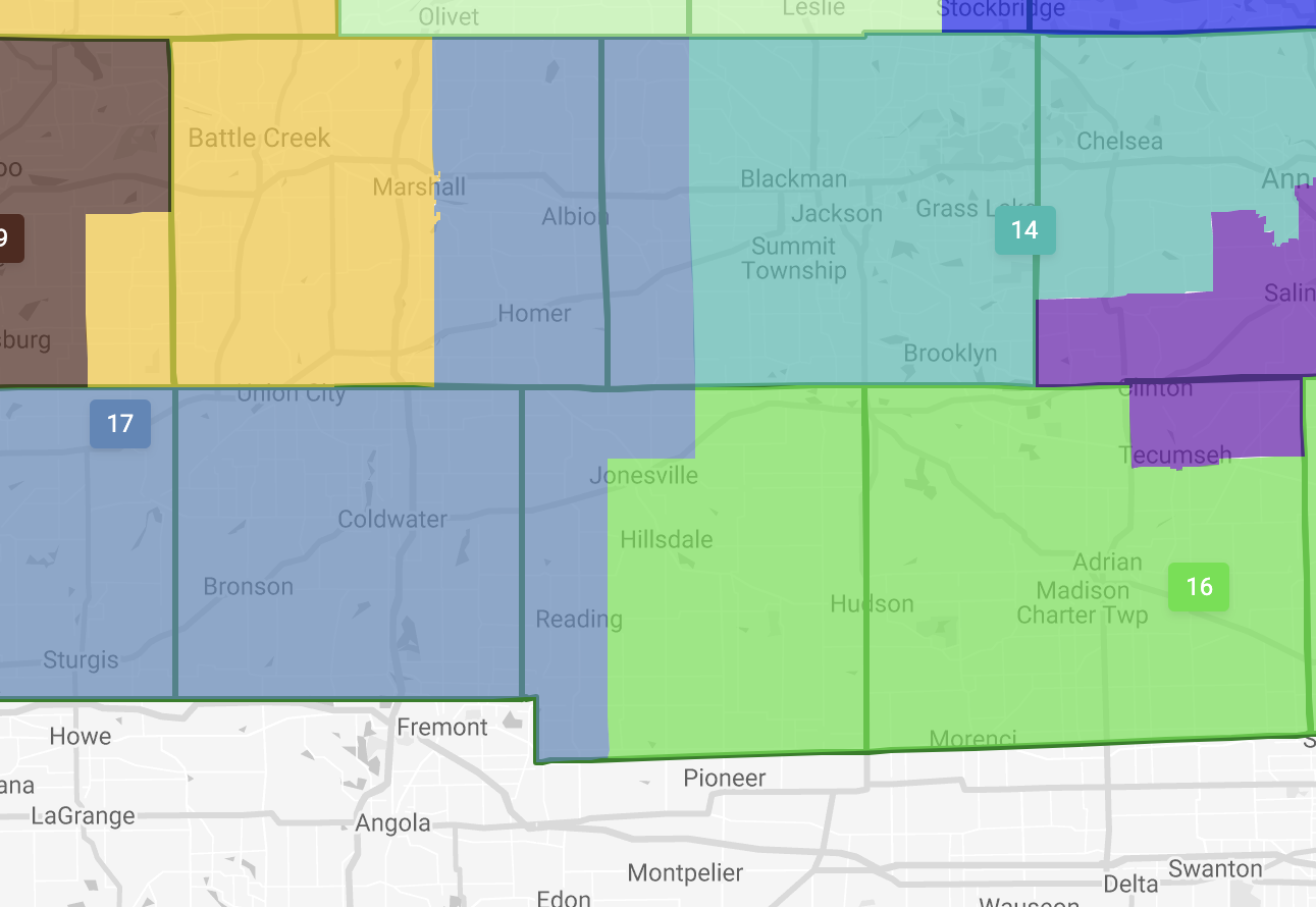
Hillsdale County will be split into two different state Senate districts under a plan approved by the Michigan Independent Citizens Redistricting Commission on Dec. 28.
On the new map, Hillsdale and Jonesville are in district 16 and Allen and Reading are in district 17.
The new maps enacted by the commission give Democrats a chance of flipping the state legislature by creating several competitive districts in suburban areas, according to Bridge Michigan.
Colin Brown, a Van Andel graduate school student who worked as a researcher for Hillsdale’s Markman Report, said the redistricting commission evaluated several factors: partisan fairness, compliance with the Voting Rights Act of 1965, the Michigan State Constitution, contiguity in crafting districts, and communities of interest. The Markman report raised questions about the communities of interest requirement, according to Brown.
“The introduction of communities of interest had not played a role in previous redistricting efforts,” Brown said.
Brown said the University of Michigan’s Center for Local, State, and Urban Policy penned a report interpreting the communities of interest requirement to be expanded to encompass issues of public policy such as special tax assessment districts and media markets. Hillsdale College responded to the report with the Markman Report, written by former Michigan Supreme Court Justice and Professor of Constitutional Law Stephen Markman.
The Markman report interprets communities of interest as organic counties, cities, towns, villages, and townships. Markman writes that the University of Michigan report’s interpretation of “communities of interest” could risk bringing elements of gerrymandering and political partisanship into the redistricting process under a different name.
“It is very clear that the commission used communities of interest as a way of moving away from traditional geographical and pre-established political boundaries,” Brown said. “In some of the early versions of the maps, Hillsdale County was sometimes split into two or three statehouse districts.”
Voters established the Michigan Redistricting Commission by approving an amendment to the Michigan State Constitution in 2018. This transferred the legislature’s power to draw state and congressional districts to an independent redistricting commission of citizens selected by lottery, according to the Michigan State Constitution.
Josh Barker, a junior and George Washington Fellow who assisted with research for the Markman project, said Democrats often argue that the number of votes and the number of seats awarded during an election are unproportional.
“By looking at partisan fairness during redistricting, people will complain about the amount of seats held by Republicans being higher than those who actually voted for them,” Barker said. “The fact lines are drawn means that it has to happen. The winner takes all, unless you bake partisan parity into the system.”
Associate Professor of Politics Joseph Postell, who closely followed the redistricting of the Michigan congressional map, said the winner-take-all system causes the “wasted vote phenomena” where every vote over the 50% threshold does not achieve more representation for that district.
“What Democrats want to do is redraw the districts so that they win each district by the smallest number of votes possible, thereby evenly distributing their voters throughout all the districts and translating their votes into as much political power as possible,” Postell said.
Hillsdale College graduate student Sam Lair, who led a petition against the county split, said the commission fundamentally changed the redistricting process with its new maps.
“The issue with the commission is that of elected officials and the original conception of the American Constitution,” Lair said. “It should be the representatives and the people duly appointed for those positions that are accountable to the people.”
According to The Detroit News, two non-partisan members of the commission who applied as independents were later traced to Democratic causes. Brown said this was one example of difficulties with independent commissions drawing district maps with minimal experience.
Lair said there was no member appointed to the redistricting commission from Southern Michigan.
Sophomore Luke Spangler, who has closely followed the redistricting process, said the commission’s efforts produced maps that better represent all aspects of Michigan under the requirements of the state Constitution.
“The maps saw much improvement to competitiveness in districts, where as much as 25% of the statehouse could easily switch parties in any given election according to previous results in those new districts,” Spangler said, citing Bridge Michigan. “While on paper the boundaries look rough, the people are picking the politicians instead of the other way around for the first time in Michigan history.”
Both districts will elect a new state Senator as Mike Shirkey, R-Clarklake, and Dale Zorn, R-Ida, will be term-limited after serving two terms of four years, according to their Michigan Senate bios.
Unlike the state Senate map, Hillsdale County will remain intact in the new maps for U.S. Congress and the state house of representatives. The Cook Political Report predicts the county will easily re-elect state representative Andrew Fink, R-Hillsdale, and U.S. Congressman Tim Walberg, R-Tipton. Fink was elected in 2020 by a margin of more than 40 points, while Walberg was elected by a 17-point margin, according to election data compiled by the Michigan Department of State.
![]()